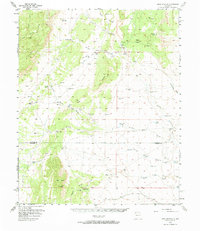
1956 Map of Mesa Aparejo
USGS Topo · Published 1973About this map
Romero Ranch and Frost Ranch anchor a landscape defined by an extensive network of water catchment systems and seasonal drainage channels in the mid-1950s. This region, straddling the border between Valencia and Socorro counties, is characterized by its high plateaus and distinct arroyo systems like Arroyo Salado and Arroyo Pato. The mapping of family-named landmarks such as Yriart Ranch and Saladito Ranch provides a clear record of land use and livestock operations during this era.
Find a feature on this map
63 named features on this map. Tap any name to fly to it.
Don’t see what you’re looking for? This feature index may not catch every label — zoom into the map to look around manually.
Map Details
Editions of this 1956 Mesa Aparejo Map
2 editions found
Other maps of this area

1916 · La Joya
USGS Topo · 1:125,000

1917 · Cerro Verde
USGS Topo · 1:125,000

1952 · La Joya NW
USGS Topo · 1:24,000

1952 · Belen SW
USGS Topo · 1:24,000

1952 · Belen NW
USGS Topo · 1:24,000

1952 · Rio Puerco
USGS Topo · 1:24,000

1954 · South Garcia SE
USGS Topo · 1:24,000

1954 · Socorro
USGS Topo · 1:250,000

1956 · South Garcia
USGS Topo · 1:62,500

1956 · Mesa Aparejo
USGS Topo · 1:62,500