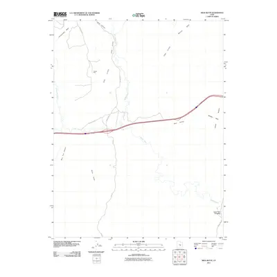
2011 Map of Mesa Butte
USGS Topo · Published 2011About this map
Coal Cliffs and the jagged edge of the Molen Reef define this desert landscape in Emery County, where the topography transition from high plateaus to deeply carved drainage basins. The map illustrates a region where water is the primary architect, with Muddy Creek meandering through the center, joined by Quitchupah Creek and Ivie Creek in the west. A network of rural routes, including Blue Rd and various county roads, connects remote points such as Lone Tree Crossing in the southeast corner. The presence of the Cowboy Mine tucked beneath the cliffs north of Red Valley points to the area's mineral interests, while landforms like Mesa Butte and Sand Bench provide essential landmarks for navigation across the arid terrain.
Find a feature on this map
21 named features on this map. Tap any name to fly to it.
Don’t see what you’re looking for? This feature index may not catch every label — zoom into the map to look around manually.
Map Details
Editions of this 2011 Mesa Butte Map
This is the sole edition of this map. No revisions or reprints were ever made.
Other maps of this area

1885 · Fish Lake
USGS Topo · 1:250,000

1896 · Fish Lake
USGS Topo · 1:250,000

1925 · Acord Lakes
USGS Topo · 1:62,500

1953 · Emery 4 NE
USGS Topo · 1:24,000

1953 · Emery 1 NE
USGS Topo · 1:24,000

1953 · Emery 1 SE
USGS Topo · 1:24,000

1956 · Salina
USGS Topo · 1:250,000

1960 · Salina
USGS Topo · 1:250,000

1962 · Salina
USGS Topo · 1:250,000
1968 · Walker Flat
USGS Topo · 1:24,000