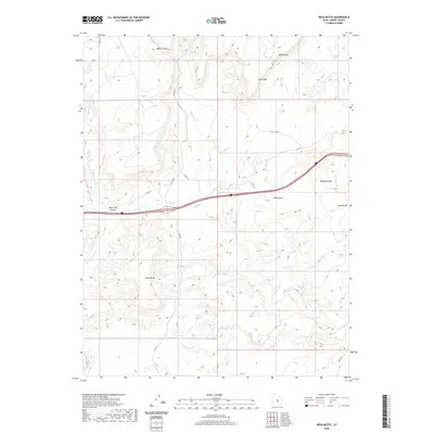
2020 Map of Mesa Butte
USGS Topo · Published 2020About this map
Mesa Butte anchors the central portion of this Emery County landscape, where the high desert terrain is defined by dramatic geological formations and intermittent drainage systems. The northern reaches of the quadrangle feature the sharp elevation changes of the Coal Cliffs and Molen Reef, while the central corridor is marked by the passage of Interstate 70 through Red Valley. This transport route runs roughly parallel to Ivie Cr and Muddy Cr, which have carved significant features like Blue Trail Canyon into the plateau. The map details a complex network of county roads, such as Co RD 912 and Co RD 917, which provide access to the remote cattle and resource lands surrounding Mulligan Wash and the Sand Bench. These labels reflect a history of land use focused on grazing and passage through the San Rafael Swell region, documenting the modern infrastructure layered over ancient canyon geography.
Find a feature on this map
18 named features on this map. Tap any name to fly to it.
Don’t see what you’re looking for? This feature index may not catch every label — zoom into the map to look around manually.
Map Details
Editions of this 2020 Mesa Butte Map
This is the sole edition of this map. No revisions or reprints were ever made.
Other maps of this area

1885 · Fish Lake
USGS Topo · 1:250,000

1896 · Fish Lake
USGS Topo · 1:250,000

1925 · Acord Lakes
USGS Topo · 1:62,500

1953 · Emery 4 NE
USGS Topo · 1:24,000

1953 · Emery 1 NE
USGS Topo · 1:24,000

1953 · Emery 1 SE
USGS Topo · 1:24,000

1956 · Salina
USGS Topo · 1:250,000

1960 · Salina
USGS Topo · 1:250,000

1962 · Salina
USGS Topo · 1:250,000
1968 · Walker Flat
USGS Topo · 1:24,000