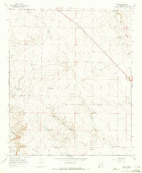
1967 Map of Mesa
USGS Topo · Published 1971About this map
Isolated ranching operations and water management systems dominate this High Plains landscape along the boundary between De Baca and Chaves counties. The geography is defined by the complex drainage of Middle Fork Fivemile Draw and West Fork Fivemile Draw, where the survival of livestock in this arid environment is evident through a dense network of man-made catchments including Brahman Calf Tank, Shortys Tank, and Bomb Target Tank. The presence of the C H Lewis Ranch and J M Lewis Ranch indicates the long-standing family ranching heritage of the region during the late 1960s. Terrain features like Poquita Mesa and the deep cuts of Fifteenmile Arroyo provide natural landmarks for a territory otherwise characterized by its openness and reliance on scattered resources like Buck Springs.
Find a feature on this map
29 named features on this map. Tap any name to fly to it.
Don’t see what you’re looking for? This feature index may not catch every label — zoom into the map to look around manually.
Map Details
Editions of this 1967 Mesa Map
2 editions found
Other maps of this area

1954 · Fort Sumner
USGS Topo · 1:250,000

1955 · Roswell
USGS Topo · 1:250,000

1958 · Fort Sumner
USGS Topo · 1:250,000

1958 · Roswell
USGS Topo · 1:250,000

1962 · Roswell
USGS Topo · 1:250,000

1967 · Wire Lake
USGS Topo · 1:24,000

1967 · Round Mountain SE
USGS Topo · 1:24,000

1967 · Round Mountain
USGS Topo · 1:24,000

1967 · Dunlap Sill
USGS Topo · 1:24,000

1967 · Devils Well
USGS Topo · 1:24,000