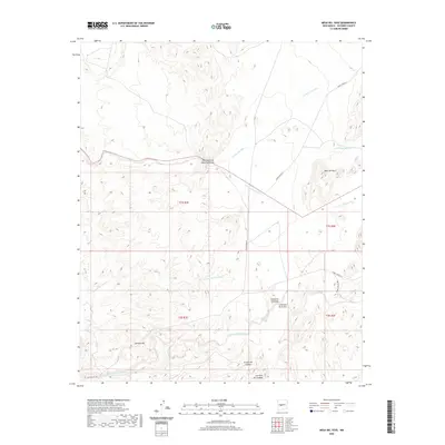
2020 Map of Mesa Del Yeso
USGS Topo · Published 2020About this map
Puertecito of Bowling Green and Cerrillos del Coyote anchor this Socorro County landscape, where complex drainage networks define the terrain. The map details a high-desert environment dominated by the prominent Mesa del Yeso and the southern rise of Johnson Hill. An intricate system of ephemeral watercourses, including Arroyo Varrido, Arroyo del Veranito, and the extensive Arroyo de la Parida, illustrates the regional hydrology. The inclusion of Ojo de la Parida suggests a vital water source in this arid expanse. Strategically placed routes such as WSMR P Route 5 cut through the sections, reflecting the modern utility and accessibility of this land south of the Ladron Mountains. Small locales like Cañoncito Colorado and Cañoncito de la Uva indicate localized geographic naming conventions tied to the arroyo and canyon systems.
Find a feature on this map
20 named features on this map. Tap any name to fly to it.
Don’t see what you’re looking for? This feature index may not catch every label — zoom into the map to look around manually.
Map Details
Editions of this 2020 Mesa Del Yeso Map
This is the sole edition of this map. No revisions or reprints were ever made.
Other maps of this area

1906 · Socorro
USGS Topo · 1:62,500

1916 · La Joya
USGS Topo · 1:125,000

1952 · San Anacia
USGS Topo · 1:24,000

1952 · La Joya
USGS Topo · 1:24,000

1952 · Becker SW
USGS Topo · 1:24,000

1954 · Socorro
USGS Topo · 1:250,000

1958 · Socorro
USGS Topo · 1:250,000

1959 · Loma De Las Canas
USGS Topo · 1:24,000

1959 · Socorro
USGS Topo · 1:24,000

1959 · Mesa Del Yeso
USGS Topo · 1:24,000