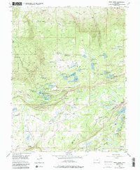
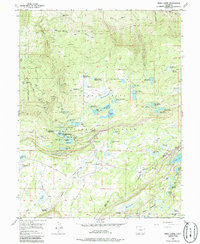
1955 Map of Mesa Lakes
USGS Topo · Published 1986About this map
Grand Mesa National Forest dominates this mid-century landscape, revealing a complex network of high-altitude water management and early forest administration. The area is defined by an intensive system of catchments and reservoirs, such as Jumbo Reservoir and the Coon Creek Reservoir No 1, which reflect the engineering required to support downstream ranching and agriculture. Settlement patterns are sparse and seasonal, centered around operations like the Beaver Homestead and working livestock sites including Bull Creek Cow Camp and Hallenbeck Cow Camp. The presence of the Mesa Lakes Ranger Station and Skyway indicates the dual role of the forest as both a managed resource and an emerging destination for recreation. The map meticulously tracks the infrastructure of the era, from the Drift Fence lines to the Spillway Aqueduct Elevated, illustrating how water was moved across the plateau through the Ditch systems.
Find a feature on this map
116 named features on this map. Tap any name to fly to it.
Don’t see what you’re looking for? This feature index may not catch every label — zoom into the map to look around manually.
Map Details
Editions of this 1955 Mesa Lakes Map
6 editions found
Other maps of this area

1955 · Collbran
USGS Topo · 1:24,000

1955 · Mesa
USGS Topo · 1:24,000

1955 · Grand Mesa
USGS Topo · 1:24,000

1955 · Molina
USGS Topo · 1:24,000

1955 · Skyway
USGS Topo · 1:24,000

1956 · Montrose
USGS Topo · 1:250,000

1956 · Moab
USGS Topo · 1:250,000

1956 · Grand Junction
USGS Topo · 1:250,000

1957 · Leadville
USGS Topo · 1:250,000

1959 · Grand Junction
USGS Topo · 1:250,000