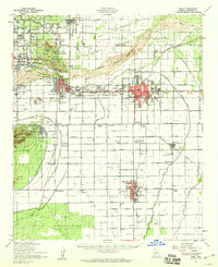
1952 Map of Mesa
USGS Topo · Published 1960About this map
Scottsdale, Tempe, and Mesa appear in the early 1950s as rapidly expanding agricultural and residential hubs defined by an intricate network of irrigation infrastructure. The Salt River corridor is central to this landscape, flanked by the Salt River Indian Reservation and punctuated by geological landmarks like Hole-in-the-Rock and Barnes Butte. This era captures Arizona State College before its transition to a university, alongside rural industrial markers like the Kyrene Steam Generating Plant and numerous Grain Elevators in Chandler.
Find a feature on this map
91 named features on this map. Tap any name to fly to it.
Don’t see what you’re looking for? This feature index may not catch every label — zoom into the map to look around manually.
Map Details
Editions of this 1952 Mesa Map
This is the sole edition of this map. No revisions or reprints were ever made.
Other maps of this area

1904 · Camelback
USGS Topo · 1:62,500

1904 · Desert Well
USGS Topo · 1:62,500

1904 · Ft. McDowell
USGS Topo · 1:62,500

1906 · Camelsback
USGS Topo · 1:62,500

1906 · Ft. McDowell
USGS Topo · 1:62,500

1906 · Desert Well
USGS Topo · 1:62,500

1907 · Sacaton
USGS Topo · 1:62,500

1912 · Phoenix
USGS Topo · 1:62,500

1913 · Mesa
USGS Topo · 1:62,500

1913 · Maricopa
USGS Topo · 1:62,500