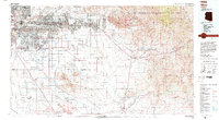
1994 Map of Mesa
USGS Topo · Published 1994About this map
The Superstition Mountains and the Superstition Wilderness dominate the northeastern landscape of this 1994 topographic survey, where the expanding urban footprint of Mesa and Tempe meets the high desert. In the valley, the Salt River and Gila River frame the ancestral lands of the Salt River Indian Reservation and the Gila River Indian Reservation, showcasing a region defined by ancient history and modern industry. Significant archaeological sites are preserved at the Hohokam Pima Nat Monument and Casa Grande Ruins Nat Mon.
Find a feature on this map
107 named features on this map. Tap any name to fly to it.
Don’t see what you’re looking for? This feature index may not catch every label — zoom into the map to look around manually.
Map Details
Editions of this 1994 Mesa Map
2 editions found
Other maps of this area

1900 · Florence
USGS Topo · 1:125,000

1901 · Globe
USGS Topo · 1:62,500

1902 · Globe
USGS Topo · 1:62,500

1902 · Florence
USGS Topo · 1:125,000

1904 · Camelback
USGS Topo · 1:62,500

1904 · Desert Well
USGS Topo · 1:62,500

1904 · Ft. McDowell
USGS Topo · 1:62,500

1906 · Camelsback
USGS Topo · 1:62,500

1906 · Ft. McDowell
USGS Topo · 1:62,500

1906 · Desert Well
USGS Topo · 1:62,500