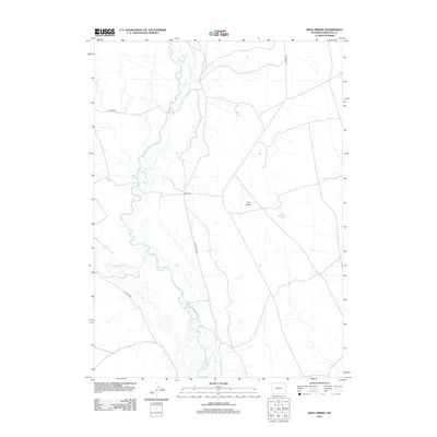
2012 Map of Mesa Spring
USGS Topo · Published 2012About this map
The Green River snakes through the western portion of this Sublette County landscape, its winding course defining the riverine corridor before the terrain rises eastward toward the flat-topped expanse of The Mesa. This high-desert region is marked by its arid hydrology, where isolated water sources like Mesa Spring and the Bloom Reservoir provide critical points of relief. The map reveals a network of utilitarian transit, where established routes like E Green River Rd and The Mesa Rd connect the river valley to the higher plateau. To the south, Cottonwood Cr feeds toward the main river channel, while the straight lines of Chapel Rd and Luman Rd suggest the systematic land division of the Bureau of Land Management, which manages much of this open rangeland. The combination of intricate river meanders and the broad, open benchland of the mesa illustrates the classic topographical contrast of the Wyoming basin.
Find a feature on this map
10 named features on this map. Tap any name to fly to it.
Don’t see what you’re looking for? This feature index may not catch every label — zoom into the map to look around manually.
Map Details
Editions of this 2012 Mesa Spring Map
This is the sole edition of this map. No revisions or reprints were ever made.
Other maps of this area

1939 · Big Piney
USGS Topo · 1:125,000

1942 · Big Piney
USGS Topo · 1:125,000

1955 · Preston
USGS Topo · 1:250,000

1955 · Lander
USGS Topo · 1:250,000

1958 · Lander
USGS Topo · 1:250,000

1958 · Preston
USGS Topo · 1:250,000

1961 · Lander
USGS Topo · 1:250,000

1962 · Preston
USGS Topo · 1:250,000

1964 · Two Buttes Reservoir
USGS Topo · 1:24,000

1964 · Ross Butte
USGS Topo · 1:24,000