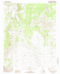
1985 Map of Mesas Mojinas
USGS Topo · Published 1985About this map
Mesas Mojinas and the surrounding high desert of Valencia County are defined by a network of seasonal watercourses and upland mesas that dictated the movement of cattle and ranching operations in the late 20th century. The drainage patterns of Arroyo Salado, Arroyo Comanche, and Arroyo Monte carve through the landscape, flanked by prominent elevations such as Mesa Carrizo and Mesa Aparejo. This mid-1980s provisional survey shows a terrain developed for livestock management, indicated by numerous family-named and functional water catchments like Gurule Tank, Alderete Tank, Esperanza Tank, and Shipping Tank. Near the base of the mesas, several Quarries suggest small-scale resource extraction alongside the primary ranching economy. The map provides a clear look at the rural infrastructure of the period, from the isolated House Tank to the more remote Sabina Tank in the southern reaches of the quadrangle.
Find a feature on this map
15 named features on this map. Tap any name to fly to it.
Don’t see what you’re looking for? This feature index may not catch every label — zoom into the map to look around manually.
Map Details
Editions of this 1985 Mesas Mojinas Map
This is the sole edition of this map. No revisions or reprints were ever made.
Other maps of this area

1917 · Cerro Verde
USGS Topo · 1:125,000

1952 · Belen SW
USGS Topo · 1:24,000

1952 · Belen NW
USGS Topo · 1:24,000

1952 · Rio Puerco
USGS Topo · 1:24,000

1954 · South Garcia SE
USGS Topo · 1:24,000

1954 · Socorro
USGS Topo · 1:250,000

1956 · South Garcia
USGS Topo · 1:62,500

1956 · Mesa Aparejo
USGS Topo · 1:62,500

1958 · Socorro
USGS Topo · 1:250,000

1962 · Socorro
USGS Topo · 1:250,000