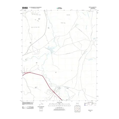
2010 Map of Mesita
USGS Topo · Published 2010About this map
Mesita and its surrounding plateau landscape are defined by the convergence of the Rio San Jose and the Rio Paguate, where the community sits amidst a network of canyon mesas. The infrastructure is characterized by an extensive system of Indian Service Routes, including Indian Service Route 521 and Indian Service Route 52, which link the main settlement to outliers like Marmon and El Rito. Industrial activity is evident through mineral extraction sites such as the H-1 Mine and the Oak Creek Canyon Deposit, while water management is highlighted by the Paguate Reservoir and Mesita Well. The terrain is marked by prominent landmarks like Sunhouse Peaks and Heart Peak, which rise above the surrounding flats of Snowbird Mesa and Wiener Mesa, illustrating the geographic diversity of this Cibola County region in the early 21st century.
Find a feature on this map
36 named features on this map. Tap any name to fly to it.
Don’t see what you’re looking for? This feature index may not catch every label — zoom into the map to look around manually.
Map Details
Editions of this 2010 Mesita Map
This is the sole edition of this map. No revisions or reprints were ever made.
Other maps of this area

1883 · Mt. Taylor
USGS Topo · 1:250,000

1886 · Mt. Taylor
USGS Topo · 1:250,000

1892 · Mt. Taylor
USGS Topo · 1:250,000

1899 · Mt. Taylor
USGS Topo · 1:250,000

1917 · Cerro Verde
USGS Topo · 1:125,000

1954 · Socorro
USGS Topo · 1:250,000

1956 · South Garcia
USGS Topo · 1:62,500

1957 · Laguna
USGS Topo · 1:24,000
1957 · Mesa Gigante
USGS Topo · 1:24,000

1957 · Moquino
USGS Topo · 1:24,000