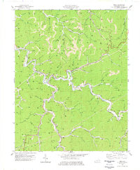
1978 Map of Meta
USGS Topo · Published 1978About this map
Johns Creek winds through this Central Appalachian landscape, serving as the primary corridor for the Chesapeake and Ohio railroad and the cluster of settlements like Meta and Zebulon. By the late 1970s, the terrain reveals a complex industrial pattern where extensive strip mine operations and gas wells sit alongside rural community pillars like the Pilgrims Home Sch, Johns Creek High Sch, and Salem Church. The map illustrates the region's reliance on both extractive industry and the narrow valley floors for development, with features like the Morris Tipple indicating the infrastructure of the coal trade. High points such as Bent Mountain and Pinson Ridge overlook the branching hollows, while the presence of the Lookout Tower and numerous family burial sites, including the Williamson Cem, provide a detailed record of the local genealogy and land use during this era.
Find a feature on this map
78 named features on this map. Tap any name to fly to it.
Don’t see what you’re looking for? This feature index may not catch every label — zoom into the map to look around manually.
Map Details
Editions of this 1978 Meta Map
This is the sole edition of this map. No revisions or reprints were ever made.
Other maps of this area

1886 · Prestonsburg
USGS Topo · 1:125,000

1886 · Grundy
USGS Topo · 1:125,000

1887 · Warfield
USGS Topo · 1:125,000

1890 · Whitesburg
USGS Topo · 1:125,000

1890 · Grundy
USGS Topo · 1:125,000

1891 · Warfield
USGS Topo · 1:125,000

1892 · Grundy
USGS Topo · 1:125,000

1892 · Whitesburg
USGS Topo · 1:125,000

1892 · Prestonsburg
USGS Topo · 1:125,000

1914 · Laynesville
USGS Topo · 1:48,000