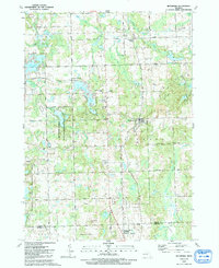
1991 Map of Metamora
USGS Topo · Published 1991About this map
Lake Metamora and the surrounding Lapeer County countryside are defined by a complex network of glacial kettle lakes and marshy drains during this late-century period. The village of Metamora serves as the central hub, situated along the Old Grade and Dryden Road corridor. The landscape is a mix of agricultural land and state-managed conservation, notably the Metamora-Hadley State Recreation Area which occupies the western portion of the quadrangle.
Find a feature on this map
64 named features on this map. Tap any name to fly to it.
Don’t see what you’re looking for? This feature index may not catch every label — zoom into the map to look around manually.
Map Details
Editions of this 1991 Metamora Map
This is the sole edition of this map. No revisions or reprints were ever made.
Other maps of this area

1943 · Ortonville
USGS Topo · 1:24,000

1943 · Lake Orion
USGS Topo · 1:24,000

1943 · Oxford
USGS Topo · 1:24,000

1943 · Metamora
USGS Topo · 1:24,000

1945 · Thornville
USGS Topo · 1:24,000

1945 · Oxford
USGS Topo · 1:24,000
1945 · Ortonville
USGS Topo · 1:24,000

1945 · Hadley
USGS Topo · 1:24,000
1945 · Lake Orion
USGS Topo · 1:24,000

1946 · Metamora
USGS Topo · 1:24,000
Featured Places
- Oxford Charter Township, MI
- Metamora, MI
- Brandon Charter Township, MI
- Hadley Township, MI
- Elba Township, MI