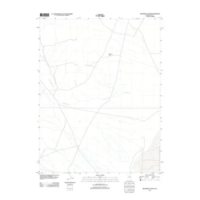
2012 Map of Meteorite Crater
USGS Topo · Published 2012About this map
Meteorite Crater defines the center of this Nye County landscape, where the arid terrain is shaped by an intricate network of seasonal drainage patterns. This 2012 survey illustrates the hydrological character of the high desert, primarily through the winding paths of Ike Spring Wash and Little Ike Spring Wash. These ephemeral watercourses traverse the area, revealing the natural erosional flow toward the southeast. Toward the lower right, the presence of Trap Spring indicates a localized water source in an otherwise dry environment. The map provides a clear record of the area's physical geography at the beginning of the 21st century, detailing the primitive road network that navigates this stark geological setting.
Find a feature on this map
4 named features on this map. Tap any name to fly to it.
Don’t see what you’re looking for? This feature index may not catch every label — zoom into the map to look around manually.
Map Details
Editions of this 2012 Meteorite Crater Map
This is the sole edition of this map. No revisions or reprints were ever made.
Other maps of this area

1956 · Lund
USGS Topo · 1:250,000

1960 · Lund
USGS Topo · 1:250,000

1964 · Blue Eagle Springs
USGS Topo · 1:62,500

1964 · Duckwater
USGS Topo · 1:62,500

1968 · Portuguese Mtn
USGS Topo · 1:62,500
1968 · Sand Spring
USGS Topo · 1:24,000

1968 · Portuguese Mtn
USGS Topo · 1:24,000
1968 · Lockes
USGS Topo · 1:24,000

1980 · Duckwater
USGS Topo · 1:100,000
1990 · Bradshaw Spring
USGS Topo · 1:24,000