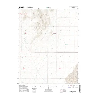
2014 Map of Meteorite Crater
USGS Topo · Published 2014About this map
Meteorite Crater dominates the central topography of this high-desert landscape in eastern Nye County. The 2014 survey captures a terrain defined by arid drainage patterns, most notably Ike Spring Wash and Little Ike Spring Wash, which cut through the complex contouring of the central peaks. The map reveals an area nearly devoid of permanent structures or modern developments, preserved instead in its raw geological state as part of the Basin and Range province. Near the southern boundary, Trap Spring indicates one of the rare water sources in this dry environment. The cadastral grid established by the Public Land Survey System provides the primary human-imposed structure across the sheet, delineating townships like t10n r56e and t9n r56e against the backdrop of ancient impact geology and seasonal watercourses.
Find a feature on this map
10 named features on this map. Tap any name to fly to it.
Don’t see what you’re looking for? This feature index may not catch every label — zoom into the map to look around manually.
Map Details
Editions of this 2014 Meteorite Crater Map
This is the sole edition of this map. No revisions or reprints were ever made.
Other maps of this area

1956 · Lund
USGS Topo · 1:250,000

1960 · Lund
USGS Topo · 1:250,000

1964 · Blue Eagle Springs
USGS Topo · 1:62,500

1964 · Duckwater
USGS Topo · 1:62,500

1968 · Portuguese Mtn
USGS Topo · 1:62,500
1968 · Sand Spring
USGS Topo · 1:24,000

1968 · Portuguese Mtn
USGS Topo · 1:24,000
1968 · Lockes
USGS Topo · 1:24,000

1980 · Duckwater
USGS Topo · 1:100,000
1990 · Bradshaw Spring
USGS Topo · 1:24,000