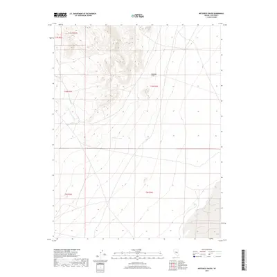
2018 Map of Meteorite Crater
USGS Topo · Published 2018About this map
Meteorite Crater dominates the central landscape of this eastern Nye County terrain, serving as a prominent geographical landmark amid a complex system of drainage washes. The map illustrates the hydrological patterns of the High Desert, where ephemeral watercourses like Ike Spring Wash and Little Ike Spring Wash carve through the basin and range topography. These seasonal drainage networks, alongside isolated water sources like Trap Spring, were historically critical for movement and survival in this arid interior region of Nevada.
Find a feature on this map
9 named features on this map. Tap any name to fly to it.
Don’t see what you’re looking for? This feature index may not catch every label — zoom into the map to look around manually.
Map Details
Editions of this 2018 Meteorite Crater Map
This is the sole edition of this map. No revisions or reprints were ever made.
Other maps of this area

1956 · Lund
USGS Topo · 1:250,000

1960 · Lund
USGS Topo · 1:250,000

1964 · Blue Eagle Springs
USGS Topo · 1:62,500

1964 · Duckwater
USGS Topo · 1:62,500

1968 · Portuguese Mtn
USGS Topo · 1:62,500
1968 · Sand Spring
USGS Topo · 1:24,000

1968 · Portuguese Mtn
USGS Topo · 1:24,000
1968 · Lockes
USGS Topo · 1:24,000

1980 · Duckwater
USGS Topo · 1:100,000
1990 · Bradshaw Spring
USGS Topo · 1:24,000