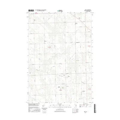
2017 Map of Metz
USGS Topo · Published 2017About this map
The community of Metz is the primary settlement in this part of Presque Isle County, sitting at a junction of roads and the N Eastern State Trail corridor. This region is notable for its high density of rural cemeteries and parish grounds, reflecting the deep immigrant and religious heritage of the area's early farmsteads. Significant sites include the Old Saint Dominic's Catholic Cem and the Saint John's Hagenville Lutheran Cem, often situated near historic town line boundaries. The landscape is defined by its agricultural grid, intersected by natural watercourses like the Swan River and Quinn Cr. Transport routes follow a systematic hierarchy, from local paths like Budnick Rd to established thoroughfares such as W Metz Hwy and Hagensville Rd. These roads link the dispersed townships and their respective community centers, such as Metz Township Cem, providing a clear view of the settlement patterns in northeastern Michigan.
Find a feature on this map
62 named features on this map. Tap any name to fly to it.
Don’t see what you’re looking for? This feature index may not catch every label — zoom into the map to look around manually.
Map Details
Editions of this 2017 Metz Map
This is the sole edition of this map. No revisions or reprints were ever made.
Other maps of this area

1954 · Alpena
USGS Topo · 1:250,000

1955 · Hillman
USGS Topo · 1:62,500

1957 · Alpena
USGS Topo · 1:250,000

1958 · Alpena
USGS Topo · 1:250,000

1969 · Alpena
USGS Topo · 1:250,000

1971 · Rogers City
USGS Topo · 1:24,000

1971 · Hawks
USGS Topo · 1:24,000

1971 · Metz
USGS Topo · 1:24,000
1971 · Moltke
USGS Topo · 1:24,000
1971 · Adams Point
USGS Topo · 1:24,000