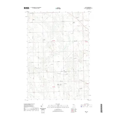
2019 Map of Metz
USGS Topo · Published 2019About this map
The Swan River meanders through this portion of Presque Isle County, where the small agricultural settlements of Metz and Hagensville anchor a landscape defined by its deep Lutheran and Catholic heritage. The map serves as an exceptional resource for genealogists, detailing numerous burial grounds including the New German Lutheran Cem, Saint Dominic's Catholic Cem, and the Old Evangelist Lutheran Cem. The rural road network, with its local highway designations like W Metz Hwy and E Ristow Hwy, reflects a long-established pattern of section-line farming. The N Eastern State Trail cuts a diagonal path across the township, following a former rail corridor that once linked these timber and farming communities. From the Metz Township Cem to the headwaters of Quinn Cr, the survey documents a quiet corner of Northern Michigan where family names are etched into the very topography of the land.
Find a feature on this map
68 named features on this map. Tap any name to fly to it.
Don’t see what you’re looking for? This feature index may not catch every label — zoom into the map to look around manually.
Map Details
Editions of this 2019 Metz Map
This is the sole edition of this map. No revisions or reprints were ever made.
Other maps of this area

1954 · Alpena
USGS Topo · 1:250,000

1955 · Hillman
USGS Topo · 1:62,500

1957 · Alpena
USGS Topo · 1:250,000

1958 · Alpena
USGS Topo · 1:250,000

1969 · Alpena
USGS Topo · 1:250,000

1971 · Rogers City
USGS Topo · 1:24,000

1971 · Hawks
USGS Topo · 1:24,000

1971 · Metz
USGS Topo · 1:24,000
1971 · Moltke
USGS Topo · 1:24,000
1971 · Adams Point
USGS Topo · 1:24,000