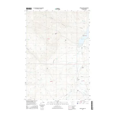
2017 Map of Metzel Ranch
USGS Topo · Published 2017About this map
Metzel Ranch and the Upper Ruby Cem stand as quiet markers of the ranching heritage in Madison County. The landscape is defined by the flow of the Ruby River and its accompanying Ruby River Reservoir, with the Pioneer Ditch irrigation system demonstrating how water was managed for agriculture in this high-elevation terrain. Notable geological and archaeological landmarks such as Table Mtn and the Buffalo Jumps provide context for the area's ancient and indigenous history. The map records several natural water sources including Puller Hot Springs, Caldwell Springs, and the marshy Brunzell Slough. Diverse landforms like Fossil Basin and Antelope Basin punctuate the ridges, while various drainages such as Idaho Cr and Mormon Cr feed the valley floor, illustrating a complex network of seasonal and permanent water throughout the territory.
Find a feature on this map
44 named features on this map. Tap any name to fly to it.
Don’t see what you’re looking for? This feature index may not catch every label — zoom into the map to look around manually.
Map Details
Editions of this 2017 Metzel Ranch Map
This is the sole edition of this map. No revisions or reprints were ever made.
Other maps of this area

1893 · Dillon
USGS Topo · 1:250,000

1955 · Dillon
USGS Topo · 1:250,000

1957 · Dillon
USGS Topo · 1:250,000

1958 · Dillon
USGS Topo · 1:250,000

1961 · Mine Gulch
USGS Topo · 1:24,000

1961 · Red Canyon
USGS Topo · 1:24,000

1961 · Beaverhead Rock SE
USGS Topo · 1:24,000

1962 · Dillon
USGS Topo · 1:250,000
1963 · Metzel Ranch
USGS Topo · 1:24,000
1963 · Home Park Ranch
USGS Topo · 1:24,000