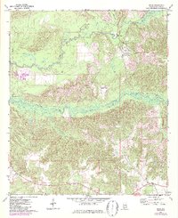
1972 Map of Mexia
USGS Topo · Published 1987About this map
Perdue Hill and the small settlement of Mexia anchor this survey of southern Monroe County, conducted in the early 1970s and updated with mid-1980s data. The landscape is defined by the winding course of Big Flat Creek and Limestone Creek, which carve through a mosaic of timberland and clearings. Transportation and communication infrastructure is evident through the Burlington Northern rail line and a prominent Radio Tower near the southern boundary. Local community life is marked by the Victoria Ch and several scattered cemeteries, providing a detailed record for genealogists. Notable landmarks such as the Hixon Lookout Tower and a Landing Strip near Fountain reflect the region's management of its extensive forest resources. The inclusion of checked fence and field lines from aerial photography provides a rare look at the fine-grained property boundaries and agricultural patterns of the era.
Find a feature on this map
18 named features on this map. Tap any name to fly to it.
Don’t see what you’re looking for? This feature index may not catch every label — zoom into the map to look around manually.
Map Details
Editions of this 1972 Mexia Map
2 editions found
Other maps of this area

1953 · Andalusia
USGS Topo · 1:250,000

1957 · Andalusia
USGS Topo · 1:250,000

1972 · Monroeville
USGS Topo · 1:24,000

1972 · Frisco City
USGS Topo · 1:24,000

1972 · Natchez
USGS Topo · 1:24,000

1972 · Franklin
USGS Topo · 1:24,000

1972 · Excel
USGS Topo · 1:24,000

1972 · Mexia
USGS Topo · 1:24,000

1972 · Flynns Lake
USGS Topo · 1:24,000

1972 · Claiborne
USGS Topo · 1:24,000