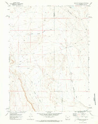
1970 Map of Mexican Flats NW
USGS Topo · Published 1973About this map
The Continental Divide cuts diagonally across this high-desert landscape on the border of Sweetwater and Carbon counties. Tracing the historic path of western migration, the Overland Trail is clearly delineated as it moves through the arid terrain, offering a specialized look at the physical remnants of the 19th-century corridor as they remained in 1970. The drainage patterns are defined by the North Barrel Springs Draw and Barrel Springs Draw, which channel intermittent water toward the north. This 1970 field-checked survey also identifies modern resource exploration with a marked Drill Hole and a network of Jeep Trails that crisscross the sagebrush flats near Coal Bank Lake. It is a stark representation of the Red Desert region, where historic trails and modern energy development converge.
Find a feature on this map
8 named features on this map. Tap any name to fly to it.
Don’t see what you’re looking for? This feature index may not catch every label — zoom into the map to look around manually.
Map Details
Editions of this 1970 Mexican Flats NW Map
This is the sole edition of this map. No revisions or reprints were ever made.
Other maps of this area

1954 · Rawlins
USGS Topo · 1:250,000

1954 · Rock Springs
USGS Topo · 1:250,000

1958 · Rawlins
USGS Topo · 1:250,000

1958 · Rock Springs
USGS Topo · 1:250,000

1962 · Rawlins
USGS Topo · 1:250,000

1962 · Rock Springs
USGS Topo · 1:250,000

1966 · High Point
USGS Topo · 1:24,000

1966 · Eightmile Lake
USGS Topo · 1:24,000

1967 · Rawlins
USGS Topo · 1:250,000

1970 · South Barrel Spring
USGS Topo · 1:24,000