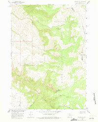
1960 Map of Mexican Hill
USGS Topo · Published 1974About this map
Bighorn National Forest dominates this high-altitude landscape along the border of Big Horn and Sheridan counties. The terrain is defined by dramatic elevation changes, notably the steep drop into Devil Canyon and the prominent heights of Sheep Mountain. In the northern section, Cookstove Basin provides a broad topographical bowl, while the drainage network includes the headwaters of Trout Creek and Bucking Mule Creek, the latter featuring Bucking Mule Falls. This mid-century survey reveals a wilderness mostly accessible via a network of foot trails and jeep trails. Human presence is sparse, limited to scattered infrastructure like Cow Camp and named landmarks such as Mexican Hill and Hannans Coulee. The map provides a detailed view of the complex water systems in this region, including Railroad Springs and the convergence of Big Tepee Creek and Little Tepee Creek in the south.
Find a feature on this map
23 named features on this map. Tap any name to fly to it.
Don’t see what you’re looking for? This feature index may not catch every label — zoom into the map to look around manually.
Map Details
Editions of this 1960 Mexican Hill Map
2 editions found

Other maps of this area

1894 · St. Xavier
USGS Topo · 1:125,000

1898 · Bald Mountain
USGS Topo · 1:125,000

1901 · St. Xavier
USGS Topo · 1:125,000

1901 · Bald Mountain
USGS Topo · 1:125,000

1954 · Billings
USGS Topo · 1:250,000

1954 · Hardin
USGS Topo · 1:250,000

1955 · Cody
USGS Topo · 1:250,000

1955 · Sheridan
USGS Topo · 1:250,000

1957 · Hardin
USGS Topo · 1:250,000

1957 · Billings
USGS Topo · 1:250,000