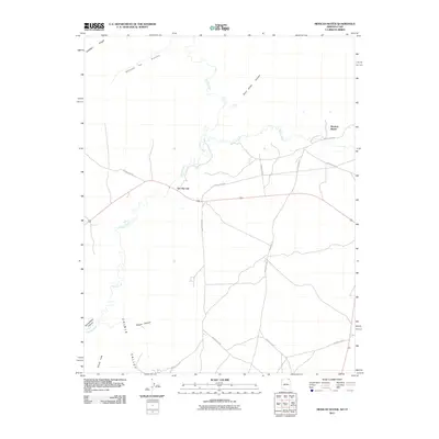
2011 Map of Mexican Water
USGS Topo · Published 2011About this map
Mexican Water and Tes Nez Iah serve as central points of settlement in this arid landscape near the Arizona-Utah border. The terrain is defined by the broad Chinle Valley and its complex system of seasonal watercourses, including the winding Chinle Creek and Walker Creek. This 2011 survey reveals an intricate network of Bureau of Indian Affairs routes, such as Indian Rte-5060 and Indian Rte-119, which provide essential connectivity through the canyon country. Notable geographic landmarks like Garnet Ridge and Shinny Mesa rise above the floor of the valley, while the erosive power of water is evident in the many named drainages such as Hosteen Tso Canyon and Wagon Canyon. The map records a modern moment in the Shiprock Agency region where traditional land use and contemporary transportation routes meet.
Find a feature on this map
19 named features on this map. Tap any name to fly to it.
Don’t see what you’re looking for? This feature index may not catch every label — zoom into the map to look around manually.
Map Details
Editions of this 2011 Mexican Water Map
2 editions found
Other maps of this area

1886 · Abajo
USGS Topo · 1:250,000

1892 · Abajo
USGS Topo · 1:250,000

1892 · Canyon De Chelly
USGS Topo · 1:250,000

1893 · Abajo
USGS Topo · 1:250,000

1952 · Bluff 3 SE
USGS Topo · 1:24,000

1952 · Dinnehotso
USGS Topo · 1:62,500

1952 · Setsiltso Springs 2 SE
USGS Topo · 1:24,000

1952 · Setsiltso Springs 2 NE
USGS Topo · 1:24,000

1954 · Shiprock
USGS Topo · 1:250,000

1956 · Cortez
USGS Topo · 1:250,000
Featured Places
- Shiprock Agency
- Mexican Water, Shiprock Agency
- Tes Nez Iah, Shiprock Agency
- Apache County, AZ
- San Juan County, UT