
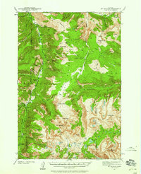
1986 Map of Meyer Mountain
USGS Topo · Published 1986About this map
High-altitude hydrology and complex terrain define this survey along the boundary between Sweet Grass and Stillwater counties. The landscape is dominated by the steep slopes of Meyer Mountain and Washburn Mountain, while the southern reaches fall within the protected Absaroka-Beartooth Wilderness. Water sources are abundant, from the West Fork Stillwater River and Pass Creek to smaller alpine features like Mountain View Lake and isolated points such as Quaker Spring and Whittaker Spring.
Find a feature on this map
40 named features on this map. Tap any name to fly to it.
Don’t see what you’re looking for? This feature index may not catch every label — zoom into the map to look around manually.
Map Details
Editions of this 1986 Meyer Mountain Map
This is the sole edition of this map. No revisions or reprints were ever made.
Other maps of this area

1891 · Livingston
USGS Topo · 1:250,000

1891 · Big Timber
USGS Topo · 1:125,000

1893 · Livingston
USGS Topo · 1:250,000

1893 · Big Timber
USGS Topo · 1:125,000

1898 · Granite Mountain District
USGS Topo · 1:125,000

1932 · Nye No 2
USGS Topo · 1:48,000
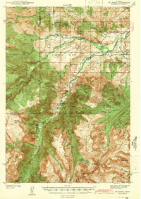
1939 · Mt Wood
USGS Topo · 1:62,500

1941 · Mt. Wood
USGS Topo · 1:62,500
1941 · Mt Douglas
USGS Topo · 1:62,500
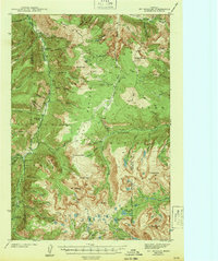
1943 · Mt Douglas
USGS Topo · 1:62,500