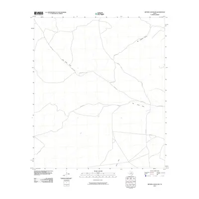
2010 Map of Meyers Canyon NE
USGS Topo · Published 2010About this map
Pumpville Rd and Longley Rd weave through a landscape defined by deep topographical drainage patterns in this corner of Val Verde County. The map is dominated by the sprawling course of Big Fielder Draw, which cuts a significant path through the center of the quadrangle. Other major landforms include Big Hackberry Canyon in the northeast and Osman Draw to the south. This network of roads, including Chapote Rd, Emery Rd, and Chapman Rd, appears to follow the natural contours of the terrain, suggesting a settlement pattern dictated by the dry washes and canyon systems. The lack of traditional town sites or dense structures highlights the open, ranching-oriented character of this West Texas region as it appeared in the early 21st century.
Find a feature on this map
11 named features on this map. Tap any name to fly to it.
Don’t see what you’re looking for? This feature index may not catch every label — zoom into the map to look around manually.
Map Details
Editions of this 2010 Meyers Canyon NE Map
This is the sole edition of this map. No revisions or reprints were ever made.
Other maps of this area

1954 · Sonora
USGS Topo · 1:250,000

1958 · Sonora
USGS Topo · 1:250,000

1973 · Post Canyon
USGS Topo · 1:24,000
1973 · Hackberry Crossing
USGS Topo · 1:24,000
1980 · Geddis Canyon East
USGS Topo · 1:24,000
1980 · Geddis Canyon West
USGS Topo · 1:24,000
1980 · Roundhill Ranch
USGS Topo · 1:24,000
1980 · Meyers Canyon NE
USGS Topo · 1:24,000
1980 · Sevenmile Canyon
USGS Topo · 1:24,000
1980 · Meyers Canyon
USGS Topo · 1:24,000