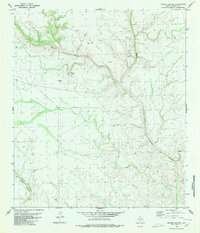
1980 Map of Meyers Canyon
USGS Topo · Published 1980About this map
Fort Meyers (Ruins) stands as a primary historical landmark in this West Texas landscape, marking a site of early frontier presence near Meyers Spring. The terrain is defined by a complex network of deep drainages, including the prominent Meyers Canyon and Big Canyon, which converge as they carve through the limestone plateau.
Find a feature on this map
11 named features on this map. Tap any name to fly to it.
Don’t see what you’re looking for? This feature index may not catch every label — zoom into the map to look around manually.
Map Details
Editions of this 1980 Meyers Canyon Map
This is the sole edition of this map. No revisions or reprints were ever made.
Other maps of this area

1918 · Dryden Crossing
USGS Topo · 1:62,500

1928 · Sanderson
USGS Topo · 1:125,000

1943 · Malvado
USGS Topo · 1:62,500

1944 · Malvado
USGS Topo · 1:62,500

1954 · Fort Stockton
USGS Topo · 1:250,000

1954 · Sonora
USGS Topo · 1:250,000

1958 · Sonora
USGS Topo · 1:250,000

1958 · Fort Stockton
USGS Topo · 1:250,000

1958 · Del Rio
USGS Topo · 1:250,000

1959 · Emory Peak
USGS Topo · 1:250,000