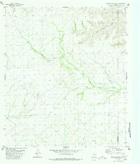
1980 Map of Meyers Canyon NE
USGS Topo · Published 1980About this map
Arid drainage systems define this West Texas landscape along the border of Terrell Co and Val Verde Co. The terrain is dominated by the deep incisions of Big Hackberry Canyon in the northeast and the meandering course of Big Fielder Draw, which cuts diagonally across the center of the sheet. These dry watercourses are characteristic of the Edwards Plateau's western reaches, where water management and seasonal runoff dictated the layout of remote ranching outposts. In the southern portion of the map, Osman Draw further illustrates the complex network of ephemeral streams that shaped regional movement and land use during the late twentieth century. This survey, based on 1974 aerial photography, provides a clear record of the topographic relief and natural boundaries in a sparsely settled section of the Trans-Pecos region.
Find a feature on this map
4 named features on this map. Tap any name to fly to it.
Don’t see what you’re looking for? This feature index may not catch every label — zoom into the map to look around manually.
Map Details
Editions of this 1980 Meyers Canyon NE Map
This is the sole edition of this map. No revisions or reprints were ever made.
Other maps of this area

1954 · Sonora
USGS Topo · 1:250,000

1958 · Sonora
USGS Topo · 1:250,000

1973 · Post Canyon
USGS Topo · 1:24,000
1973 · Hackberry Crossing
USGS Topo · 1:24,000
1980 · Geddis Canyon East
USGS Topo · 1:24,000
1980 · Geddis Canyon West
USGS Topo · 1:24,000
1980 · Roundhill Ranch
USGS Topo · 1:24,000
1980 · Sevenmile Canyon
USGS Topo · 1:24,000
1980 · Meyers Canyon
USGS Topo · 1:24,000
1980 · Meyers Canyon NW
USGS Topo · 1:24,000