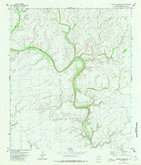
1980 Map of Meyers Canyon NW
USGS Topo · Published 1980About this map
Big Canyon dominates the landscape of this portion of Terrell County, carving a dramatic, winding path across the terrain. This 1980 survey, based on 1974 aerial photography, illustrates a remote ranching environment defined more by its natural topography than by permanent settlements. The lack of towns is replaced by a network of local transport, primarily the Jeep Trail routes that navigate the high ground and canyon floors to connect water sources and livestock infrastructure. Scattered landmarks such as the Tank symbols indicate essential water catchments for cattle in this arid West Texas environment. The map provides a clear picture of the land-use patterns in the Trans-Pecos region, where infrastructure is minimal and focused entirely on the demands of large-scale rangeland management.
Find a feature on this map
3 named features on this map. Tap any name to fly to it.
Don’t see what you’re looking for? This feature index may not catch every label — zoom into the map to look around manually.
Map Details
Editions of this 1980 Meyers Canyon NW Map
This is the sole edition of this map. No revisions or reprints were ever made.
Other maps of this area

1928 · Sanderson
USGS Topo · 1:125,000

1954 · Fort Stockton
USGS Topo · 1:250,000

1954 · Sonora
USGS Topo · 1:250,000

1958 · Sonora
USGS Topo · 1:250,000

1958 · Fort Stockton
USGS Topo · 1:250,000

1968 · Dryden
USGS Topo · 1:24,000

1969 · Continental Ranch
USGS Topo · 1:24,000

1969 · Dryden NE
USGS Topo · 1:24,000

1973 · Fort Stockton
USGS Topo · 1:250,000
1980 · Geddis Canyon East
USGS Topo · 1:24,000