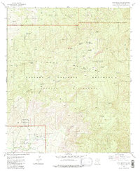
1981 Map of Mica Mountain
USGS Topo · Published 1985About this map
The Rincon Mountains dominate this high-desert landscape, captured in the early 1980s when the region was managed as a vast corridor of protected wilderness and forest. The terrain rises sharply from Rincon Creek in the south toward the high peaks of Mica Mountain and Spud Rock. Remote outposts and human presence are few but significant, including the historic high-altitude Manning Camp and the Spud Rock Cabin (Site). The presence of a Grave and a Mine near the southern boundary of the Coronado National Forest points to earlier eras of ranching and prospecting that predated the establishment of the Saguaro Wilderness. Lookout points like the Happy Valley Lookout and the Lookout Tower near the mountain summit emphasize the area's critical role in regional forest fire management.
Find a feature on this map
47 named features on this map. Tap any name to fly to it.
Don’t see what you’re looking for? This feature index may not catch every label — zoom into the map to look around manually.
Map Details
Editions of this 1981 Mica Mountain Map
3 editions found
Other maps of this area

1904 · Tucson
USGS Topo · 1:125,000

1905 · Tucson
USGS Topo · 1:125,000

1945 · Redington
USGS Topo · 1:62,500

1945 · Happy Valley
USGS Topo · 1:62,500

1956 · Tucson
USGS Topo · 1:250,000

1957 · Bellota Ranch
USGS Topo · 1:62,500

1957 · Rincon Valley
USGS Topo · 1:62,500

1957 · Redington
USGS Topo · 1:62,500

1958 · Tucson
USGS Topo · 1:250,000

1958 · Happy Valley
USGS Topo · 1:62,500