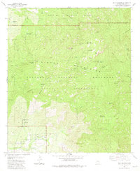
1981 Map of Mica Mountain
USGS Topo · Published 1985About this map
Mica Mountain dominates this high-elevation landscape within the Saguaro National Monument and the Saguaro Wilderness. In the early 1980s, this area served as a critical conservation and monitoring zone, evidenced by the presence of the Lookout Tower near the summit and the Happy Valley Lookout to the southeast. The map reveals human presence through back-country outposts like Manning Camp and the historic Spud Rock Cabin (Site).
Find a feature on this map
49 named features on this map. Tap any name to fly to it.
Don’t see what you’re looking for? This feature index may not catch every label — zoom into the map to look around manually.
Map Details
Editions of this 1981 Mica Mountain Map
3 editions found
Other maps of this area

1904 · Tucson
USGS Topo · 1:125,000

1905 · Tucson
USGS Topo · 1:125,000

1945 · Redington
USGS Topo · 1:62,500

1945 · Happy Valley
USGS Topo · 1:62,500

1956 · Tucson
USGS Topo · 1:250,000

1957 · Bellota Ranch
USGS Topo · 1:62,500

1957 · Rincon Valley
USGS Topo · 1:62,500

1957 · Redington
USGS Topo · 1:62,500

1958 · Tucson
USGS Topo · 1:250,000

1958 · Happy Valley
USGS Topo · 1:62,500