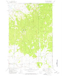
1973 Map of Mica Peak
USGS Topo · Published 1977About this map
Mica Peak dominates this landscape along the border of Spokane Co Kootenai Co, serving as a high-altitude anchor for several communication and defense facilities. The summit is home to the Mica Peak Air Force Station, along with a Radio Facility and multiple Radio Towers, reflecting its strategic role in the 1970s. The surrounding terrain is a network of watercourses including Saltese Creek, Mica Creek, and West Fork Pine Creek, while the eastern portion of the sheet transitions into Liberty Lake Regional Park.
Find a feature on this map
41 named features on this map. Tap any name to fly to it.
Don’t see what you’re looking for? This feature index may not catch every label — zoom into the map to look around manually.
Map Details
Editions of this 1973 Mica Peak Map
3 editions found
Other maps of this area

1901 · Spokane
USGS Topo · 1:125,000

1903 · Oakesdale
USGS Topo · 1:125,000

1903 · Rathdrum
USGS Topo · 1:125,000

1905 · Oakesdale
USGS Topo · 1:125,000

1949 · Greenacres
USGS Topo · 1:62,500

1951 · Greenacres
USGS Topo · 1:62,500

1954 · Fairfield
USGS Topo · 1:62,500

1955 · Spokane
USGS Topo · 1:250,000

1957 · Plummer
USGS Topo · 1:62,500

1957 · Coeur D'Alene
USGS Topo · 1:62,500