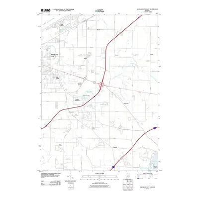
2010 Map of Michigan City East
USGS Topo · Published 2010About this map
The eastern edges of Michigan City and the shoreline of Lake Michigan anchor this 2010 landscape, where suburban expansion meets the varied hydrology of LaPorte County. The map details the drainage of Trail Creek and its East Branch, which wind through residential developments like Orchard Highlands and Trail Creek town. Infrastructure is a prominent feature, centered on the Indiana Toll Rd and its major interchanges, alongside the Michigan City Airport. Small-scale water management is visible at the Dingler Lake Dam, while the presence of several established burial grounds, including Swan Lake Memorial Gardens, Cross Cemetery, and Sharp Cemetery, provide significant points of interest for local history and genealogy. From the coastal dunes of Long Beach to the southern waters of Pine Lake and its Holmes Island, the map captures a period of modern connectivity and established community footprints.
Find a feature on this map
56 named features on this map. Tap any name to fly to it.
Don’t see what you’re looking for? This feature index may not catch every label — zoom into the map to look around manually.
Map Details
Editions of this 2010 Michigan City East Map
This is the sole edition of this map. No revisions or reprints were ever made.
Other maps of this area

1930 · Three Oaks
USGS Topo · 1:62,500

1944 · Three Oaks
USGS Topo · 1:62,500

1953 · Westville
USGS Topo · 1:24,000

1953 · Michigan City West
USGS Topo · 1:24,000

1953 · Chicago
USGS Topo · 1:250,000

1957 · Chicago
USGS Topo · 1:250,000

1958 · Michigan City East
USGS Topo · 1:24,000

1958 · La Porte East
USGS Topo · 1:24,000

1958 · Springville
USGS Topo · 1:24,000
1961 · La Porte West
USGS Topo · 1:24,000