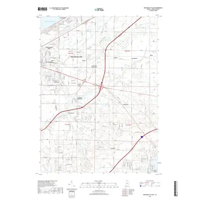
2019 Map of Michigan City East
USGS Topo · Published 2019About this map
Lake Michigan dominates the northern reaches of this coastal Indiana survey, where the residential grids of Long Beach and Michigan City transition into the managed drainage systems of the interior. The landscape is defined by an intricate network of man-made waterways including White Ditch, Brown Ditch, and Moon Ditch, which redirect the natural flow toward Trail Creek. For those tracing local history, several small cemeteries such as Cross Cem and Lows Cem are preserved among the expanding developments of Orchard Highlands and Waterford. The presence of the Michigan City Municipal Airport-Phillips Field and Pottawattomie Park highlights the mix of industrial-era utility and early 21st-century recreation that characterizes this portion of LaPorte County.
Find a feature on this map
165 named features on this map. Tap any name to fly to it.
Don’t see what you’re looking for? This feature index may not catch every label — zoom into the map to look around manually.
Map Details
Editions of this 2019 Michigan City East Map
This is the sole edition of this map. No revisions or reprints were ever made.
Other maps of this area

1930 · Three Oaks
USGS Topo · 1:62,500

1944 · Three Oaks
USGS Topo · 1:62,500

1953 · Westville
USGS Topo · 1:24,000

1953 · Michigan City West
USGS Topo · 1:24,000

1953 · Chicago
USGS Topo · 1:250,000

1957 · Chicago
USGS Topo · 1:250,000

1958 · Michigan City East
USGS Topo · 1:24,000

1958 · La Porte East
USGS Topo · 1:24,000

1958 · Springville
USGS Topo · 1:24,000
1961 · La Porte West
USGS Topo · 1:24,000