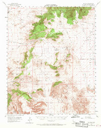
1955 Map of Mid Hills
USGS Topo · Published 1970About this map
Arid highlands and deep canyons define this landscape in the eastern Mojave, where the historic Old Government Road snakes through Cedar Canyon toward the springs at Government Holes. In the mid-1950s, this region was a network of remote mining operations and vital water sources. Prominent peaks like Columbia Mtn and Hackberry Mtn overlook a series of valleys, including Pinto Valley and Gold Valley, which supported isolated camps and shafts.
Find a feature on this map
56 named features on this map. Tap any name to fly to it.
Don’t see what you’re looking for? This feature index may not catch every label — zoom into the map to look around manually.
Map Details
Editions of this 1955 Mid Hills Map
4 editions found

Other maps of this area

1910 · Ivanpah
USGS Topo · 1:250,000

1912 · Ivanpah
USGS Topo · 1:250,000

1942 · Ivanpah
USGS Topo · 1:250,000

1942 · Amboy
USGS Topo · 1:250,000

1943 · Amboy
USGS Topo · 1:250,000

1943 · Fenner
USGS Topo · 1:62,500

1947 · Kingman
USGS Topo · 1:250,000

1948 · Kingman
USGS Topo · 1:250,000

1954 · Needles
USGS Topo · 1:250,000

1954 · Kingman
USGS Topo · 1:250,000