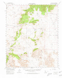
1955 Map of Mid Hills
USGS Topo · Published 1980About this map
Union Pacific rail lines cut through the northwest corner of this high desert terrain at Cima, anchoring a landscape defined by mining prospects and spring-fed cattle ranges in the mid-1950s. The map reveals a network of historic transit, including the Old Government Road winding through Round Valley past the reliable water at Government Holes. To the south, the Providence Mountains rise above Macedonia Canyon, where the Columbia Mine and several shafts mark early 20th-century extraction efforts. Significant cultural sites like Indian Petroglyphs near Woods Wash and the distinct volcanic features of Hole-in-the-Wall contrast with the industrial footprint of the Death Valley Mine and Barnett Mine. This survey serves as a vital record of Mojave Desert hydrology, charting dozens of remote water sources such as Chicken Water Spring and Mexican Water Spring that sustained life in the arid valleys.
Find a feature on this map
66 named features on this map. Tap any name to fly to it.
Don’t see what you’re looking for? This feature index may not catch every label — zoom into the map to look around manually.
Map Details
Editions of this 1955 Mid Hills Map
4 editions found

Other maps of this area

1910 · Ivanpah
USGS Topo · 1:250,000

1912 · Ivanpah
USGS Topo · 1:250,000

1942 · Ivanpah
USGS Topo · 1:250,000

1942 · Amboy
USGS Topo · 1:250,000

1943 · Amboy
USGS Topo · 1:250,000

1943 · Fenner
USGS Topo · 1:62,500

1947 · Kingman
USGS Topo · 1:250,000

1948 · Kingman
USGS Topo · 1:250,000

1954 · Needles
USGS Topo · 1:250,000

1954 · Kingman
USGS Topo · 1:250,000