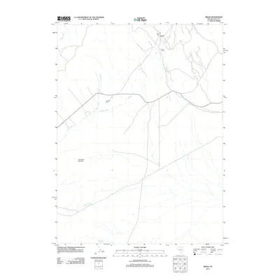
2012 Map of Midas
USGS Topo · Published 2012About this map
Midas sits at the head of Midas Creek in this northern Nevada landscape, revealing a pocket of industrial and ranching history within Elko County. The presence of the Rex Mill and the nearby Midas Cemetery points to the area's heritage as a mining district. To the west, the Wilkinson Ranch represents the high-desert agricultural operations that share this terrain with prominent landmarks like Horseshoe Mountain. The map details a network of drainage systems, including Secret Creek and Summit Creek, which flow through the basins between steep ridges. Water management is further evidenced by the Box Canyon Reservoir at the southern edge of the quadrangle, reflecting the necessity of storage in this arid environment. This survey captures a moment where early twentieth-century mining legacies and modern ranching meet along the northern Nevada corridor.
Find a feature on this map
13 named features on this map. Tap any name to fly to it.
Don’t see what you’re looking for? This feature index may not catch every label — zoom into the map to look around manually.
Map Details
Editions of this 2012 Midas Map
This is the sole edition of this map. No revisions or reprints were ever made.
Other maps of this area

1955 · McDermitt
USGS Topo · 1:250,000

1959 · McDermitt
USGS Topo · 1:250,000

1965 · Sixmile Hill
USGS Topo · 1:24,000
1965 · Jake Creek Mtn
USGS Topo · 1:24,000

1965 · Squaw Valley Ranch
USGS Topo · 1:24,000
1965 · Midas SW
USGS Topo · 1:24,000
1965 · Midas
USGS Topo · 1:24,000

1965 · Rock Creek Ranch
USGS Topo · 1:24,000

1973 · Snowstorm Mtn
USGS Topo · 1:24,000

1977 · Scraper Springs
USGS Topo · 1:24,000