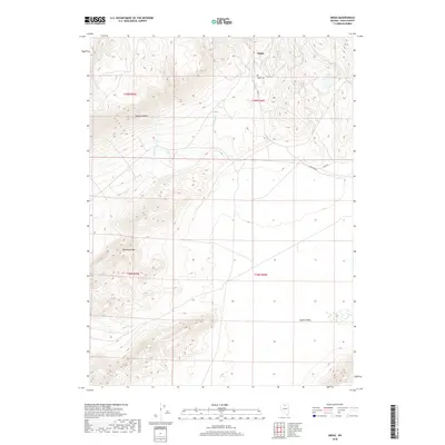
2018 Map of Midas
USGS Topo · Published 2018About this map
Midas sits at the edge of the high desert, where the settlement’s simple grid meets the base of the dramatic Owyhee Bluffs. The town’s history is reflected in its layout along Main St and the nearby Midas Cem, situated north of the main residential cluster. The surrounding terrain is defined by stark elevation changes, from the prominent Horseshoe Mtn in the southwest to the broad, flat expanse of Squaw Valley in the southeast. Water sources in this arid landscape are concentrated in seasonal drainages like Summit Cr, Spring Cr, and Clover Cr. This 2018 survey illustrates the relationship between a small, isolated Nevada settlement and the natural topography of Elko County, showing how the roads and property boundaries follow the contours of the bluffs and valley floors.
Find a feature on this map
15 named features on this map. Tap any name to fly to it.
Don’t see what you’re looking for? This feature index may not catch every label — zoom into the map to look around manually.
Map Details
Editions of this 2018 Midas Map
This is the sole edition of this map. No revisions or reprints were ever made.
Other maps of this area

1955 · McDermitt
USGS Topo · 1:250,000

1959 · McDermitt
USGS Topo · 1:250,000

1965 · Sixmile Hill
USGS Topo · 1:24,000
1965 · Jake Creek Mtn
USGS Topo · 1:24,000

1965 · Squaw Valley Ranch
USGS Topo · 1:24,000
1965 · Midas SW
USGS Topo · 1:24,000
1965 · Midas
USGS Topo · 1:24,000

1965 · Rock Creek Ranch
USGS Topo · 1:24,000

1973 · Snowstorm Mtn
USGS Topo · 1:24,000

1977 · Scraper Springs
USGS Topo · 1:24,000