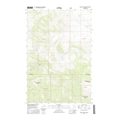
2017 Map of Middle Creek Lake
USGS Topo · Published 2017About this map
Helena National Forest lands dominate the southern half of this landscape, where the high ridges of the Big Belt Mountains dictate the flow of numerous drainages. Steep topography defines the area, with Moors Mtn and Shellrock Ridge serving as prominent local landmarks. The drainage network is complex, characterized by the headwaters of Middle Cr, which feeds into Middle Creek Lake near the center of the sheet. Further north, the terrain transitions into a series of drainages including Turell Cr and Wooden Shoe Cr.
Find a feature on this map
27 named features on this map. Tap any name to fly to it.
Don’t see what you’re looking for? This feature index may not catch every label — zoom into the map to look around manually.
Map Details
Editions of this 2017 Middle Creek Lake Map
This is the sole edition of this map. No revisions or reprints were ever made.
Other maps of this area

1886 · Great Falls
USGS Topo · 1:250,000

1886 · Fort Logan
USGS Topo · 1:250,000

1948 · White Sulphur Springs
USGS Topo · 1:250,000

1954 · Great Falls
USGS Topo · 1:250,000

1957 · Great Falls
USGS Topo · 1:250,000

1958 · White Sulphur Springs
USGS Topo · 1:250,000

1961 · White Sulphur Springs
USGS Topo · 1:250,000

1961 · Hound Creek Reservoir
USGS Topo · 1:24,000

1961 · Dana Ranch
USGS Topo · 1:24,000
1961 · The Sawteeth
USGS Topo · 1:24,000