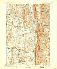
1905 Map of Middlebury
USGS Topo · Published 1935About this map
Middlebury and the surrounding townships of Addison County appear here during a period of transition, where established river-powered industry met the growing reach of the Rutland R. R. network. The landscape is defined by the prominent Hogback Mountains and South Mountain, which separate the agricultural valley floors from the higher timber and mineral lands of Starksboro and Ripton. Notable industrial remnants include the Bristol Orebed and Orebed in Monkton, highlighting the region's early mining history. The drainage of Otter Creek and the New Haven River dictated early settlement patterns, supporting clusters like New Haven Mills and Brooksville. Connectivity is shown through the historic Plank Road and the rail hub at New Haven Junction, while recreational life is marked by the Spring Grove Campground. The map preserves the footprint of several smaller communities, such as Barnumtown and Ackworth, many of which remain central to the local identity of the Champlain Valley.
Find a feature on this map
66 named features on this map. Tap any name to fly to it.
Don’t see what you’re looking for? This feature index may not catch every label — zoom into the map to look around manually.
Map Details
Editions of this 1905 Middlebury Map
5 editions found
Other maps of this area

1894 · Port Henry
USGS Topo · 1:62,500

1894 · Ticonderoga
USGS Topo · 1:62,500

1895 · Willsboro
USGS Topo · 1:62,500

1896 · Ticonderoga
USGS Topo · 1:62,500

1898 · Port Henry
USGS Topo · 1:62,500

1902 · Ticonderoga
USGS Topo · 1:62,500

1902 · Brandon
USGS Topo · 1:62,500

1903 · Middlebury
USGS Topo · 1:62,500

1904 · Brandon
USGS Topo · 1:62,500

1905 · Middlebury
USGS Topo · 1:62,500