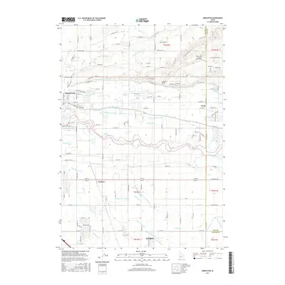
2017 Map of Middleton
USGS Topo · Published 2017About this map
Middleton and the surrounding irrigated plains of the Boise River valley are defined by an intricate network of water management systems. The landscape is bisected by the Boise River, with its associated Mason Slough and Fifteenmile Cr. The settlement pattern follows the fertile corridor between Star and Nampa, where historical agriculture relies on a dense grid of engineered waterways including the Caldwell High Line Canal, Middleton Canal, and the Farmers Union Canal. To the north, the terrain shifts from the river bottom toward the elevations of McIntyre Hill and Lanktree Gulch. Smaller localities such as Maddens are situated among the laterals and drains, illustrating the intensive land use of this region. Aviation activity is noted at Foster Field - Skydive Idaho Airport, located near the northern edge of the survey area.
Find a feature on this map
141 named features on this map. Tap any name to fly to it.
Don’t see what you’re looking for? This feature index may not catch every label — zoom into the map to look around manually.
Map Details
Editions of this 2017 Middleton Map
This is the sole edition of this map. No revisions or reprints were ever made.
Other maps of this area

1892 · Boise
USGS Topo · 1:125,000

1897 · Boise
USGS Topo · 1:125,000

1898 · Nampa
USGS Topo · 1:125,000

1953 · Meridian
USGS Topo · 1:24,000

1953 · Star
USGS Topo · 1:24,000

1953 · Montour
USGS Topo · 1:62,500

1955 · Boise
USGS Topo · 1:250,000

1958 · Boise
USGS Topo · 1:250,000
1958 · Middleton
USGS Topo · 1:24,000
1958 · Lake Lowell
USGS Topo · 1:24,000