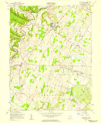
1955 Map of Middleway
USGS Topo · Published 1957About this map
Opequon Creek carves a winding path along the western edge of this mid-1950s Jefferson County landscape, where the agricultural traditions of the Shenandoah Valley meet early industrial and conservation efforts. The U S Fish Culture Station at Leetown stands as a prominent federal landmark, while the St Georges Chapel Ruins south of Aldridge offer a tangible link to the region's deeper colonial and ecclesiastical history. Settlement patterns are defined by the convergence of the Baltimore and Ohio and Norfolk and Western railroads, which serviced communities like Summit Point and Middleway. From the Stone Quarry near Johnsontown to the County Infirmary and scattered Cem sites, the map document's a localized infrastructure of labor, faith, and public service. The varied terrain is drained by numerous runs, including Turkey Run and Bullskin Run, which historically powered the mills and farms of the Kabletown and Charles Town districts.
Find a feature on this map
31 named features on this map. Tap any name to fly to it.
Don’t see what you’re looking for? This feature index may not catch every label — zoom into the map to look around manually.
Map Details
Editions of this 1955 Middleway Map
3 editions found
Other maps of this area

1884 · Harpers Ferry
USGS Topo · 1:125,000

1891 · Harpers Ferry
USGS Topo · 1:125,000

1893 · Harpers Ferry
USGS Topo · 1:125,000

1894 · Winchester
USGS Topo · 1:125,000

1914 · Martinsburg
USGS Topo · 1:48,000

1914 · Gerrardstown
USGS Topo · 1:48,000

1916 · Gerrardstown
USGS Topo · 1:62,500

1916 · Martinsburg
USGS Topo · 1:62,500

1916 · Berryville
USGS Topo · 1:62,500

1937 · Gerrardstown
USGS Topo · 1:48,000