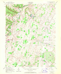
1955 Map of Middleway
USGS Topo · Published 1972About this map
Opequon Creek winds through the western edge of this Jefferson County landscape, anchoring a rural region defined by deep historical roots and established transport networks. Significant 18th-century heritage is visible at Harewood and the St Georges Chapel Ruins, marking the era of early Virginia settlement. The village of Middleway sits at a crossroads in the west, while the eastern portion is dominated by the sprawling agricultural districts of Charles Town and Kabletown. The mid-20th-century economy is reflected in specialized sites like the U S Fish Culture Station near Leetown and industrial footprints including a Stone Quarry and several Marl Pits. Connectivity across the valley is provided by the Baltimore and Ohio and Norfolk and Western railroads, which facilitated the movement of goods between small hubs like Summit Point and the larger regional markets.
Find a feature on this map
32 named features on this map. Tap any name to fly to it.
Don’t see what you’re looking for? This feature index may not catch every label — zoom into the map to look around manually.
Map Details
Editions of this 1955 Middleway Map
3 editions found
Other maps of this area

1884 · Harpers Ferry
USGS Topo · 1:125,000

1891 · Harpers Ferry
USGS Topo · 1:125,000

1893 · Harpers Ferry
USGS Topo · 1:125,000

1894 · Winchester
USGS Topo · 1:125,000

1914 · Martinsburg
USGS Topo · 1:48,000

1914 · Gerrardstown
USGS Topo · 1:48,000

1916 · Gerrardstown
USGS Topo · 1:62,500

1916 · Martinsburg
USGS Topo · 1:62,500

1916 · Berryville
USGS Topo · 1:62,500

1937 · Gerrardstown
USGS Topo · 1:48,000