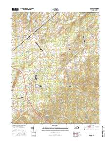
2016 Map of Midland
USGS Topo · Published 2016About this map
Germantown and the nearby Germantown Lake anchor the northwestern portion of this landscape, where the terrain slopes toward the Culpeper Basin. The area is defined by a dense network of country roads, such as Rogues RD and Midland RD, connecting small rural settlements like Elk Run, Morrisville, and Lois. Aviation history is prominent here, with several active fields and landing strips including the Warrenton-Fauquier Airport, Rhynalds Ranch Airport, and the Flying Circus Aerodrome.
Find a feature on this map
94 named features on this map. Tap any name to fly to it.
Don’t see what you’re looking for? This feature index may not catch every label — zoom into the map to look around manually.
Map Details
Editions of this 2016 Midland Map
This is the sole edition of this map. No revisions or reprints were ever made.
Other maps of this area

1887 · Spottsylvania
USGS Topo · 1:125,000

1892 · Spottsylvania
USGS Topo · 1:125,000

1894 · Warrenton
USGS Topo · 1:125,000

1894 · Warrenton
USGS Topo · 1:62,500

1927 · Remington
USGS Topo · 1:48,000

1930 · Warrenton
USGS Topo · 1:62,500

1943 · Catlett
USGS Topo · 1:62,500

1943 · Germanna Bridge
USGS Topo · 1:24,000

1943 · Midland
USGS Topo · 1:24,000
1944 · Midland
USGS Topo · 1:31,680