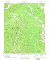
1966 Map of Midridge
USGS Topo · Published 1968About this map
Clark National Forest encompasses the high ridges and deep hollows of the Shannon and Reynolds county line, where the small settlement of Midridge sits atop Polk Ridge. This 1960s survey reveals a landscape of isolated springs and numerous named hollows, including Sugarcamp Hollow and Graveyard Hollow, which suggest the historic patterns of mountain life and land use. The presence of the Adair Creek Mine and the Himont Lookout Tower points to a dual economy of resource extraction and forest management.
Find a feature on this map
51 named features on this map. Tap any name to fly to it.
Don’t see what you’re looking for? This feature index may not catch every label — zoom into the map to look around manually.
Map Details
Editions of this 1966 Midridge Map
3 editions found
Other maps of this area

1915 · Eminence
USGS Topo · 1:62,500

1917 · Eminence
USGS Topo · 1:62,500

1928 · Cardareva
USGS Topo · 1:62,500

1944 · Corridon
USGS Topo · 1:62,500

1945 · Round Spring
USGS Topo · 1:62,500

1947 · Sinkin
USGS Topo · 1:48,000

1947 · Corridon
USGS Topo · 1:62,500

1949 · Round Spring
USGS Topo · 1:62,500

1949 · Rolla
USGS Topo · 1:250,000

1949 · Cardareva
USGS Topo · 1:62,500