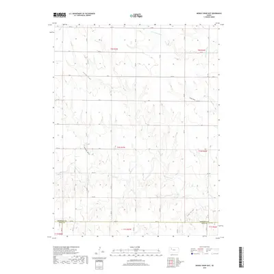
2018 Map of Midway Draw East
USGS Topo · Published 2018About this map
The N Fork Saline River and the main branch of the Saline River define the drainage of this High Plains landscape along the boundary of Sheridan and Gove counties. The terrain is characterized by a series of distinct drainage basins, including Leeds Draw, Turner Draw, Midway Draw, and Cow Draw, which reveal the erosional patterns of the western Kansas prairie. A rigid grid of township roads, such as RD 80 S and RD 100 S, provides access across the open ranching or agricultural land, intersecting at regular intervals regardless of the underlying topography. The course of Gove Cr winds through the southern sections, marking one of the few named riparian features in this arid environment during the early 21st century.
Find a feature on this map
23 named features on this map. Tap any name to fly to it.
Don’t see what you’re looking for? This feature index may not catch every label — zoom into the map to look around manually.
Map Details
Editions of this 2018 Midway Draw East Map
This is the sole edition of this map. No revisions or reprints were ever made.
Other maps of this area

1954 · Goodland
USGS Topo · 1:250,000

1956 · Goodland
USGS Topo · 1:250,000

1957 · Goodland
USGS Topo · 1:250,000

1979 · Park
USGS Topo · 1:24,000

1979 · Midway Draw West
USGS Topo · 1:24,000

1979 · Midway Draw East
USGS Topo · 1:24,000
1979 · Grainfield
USGS Topo · 1:24,000

1979 · Hoxie
USGS Topo · 1:24,000

1979 · Tasco
USGS Topo · 1:24,000

1979 · Studley
USGS Topo · 1:24,000