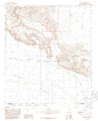
1986 Map of Midway SW
USGS Topo · Published 1986About this map
Luke Air Force Range dominates this mid-1980s landscape, illustrating the intersection of military training grounds and protected desert wilderness. The map captures a transition point where the Crater Range gives way to the broad expanse of Childs Valley, a terrain defined by desert hydrology including Midway Wash and Tenmile Wash. This era shows the southern boundary abutting the Cabeza Prieta National Wildlife Refuge, marking a significant land management border between Maricopa and Pima counties.
Find a feature on this map
10 named features on this map. Tap any name to fly to it.
Don’t see what you’re looking for? This feature index may not catch every label — zoom into the map to look around manually.
Map Details
Editions of this 1986 Midway SW Map
This is the sole edition of this map. No revisions or reprints were ever made.
Other maps of this area

1932 · Ajo
USGS Topo · 1:62,500

1934 · Ajo
USGS Topo · 1:62,500

1953 · Ajo
USGS Topo · 1:250,000

1957 · Ajo
USGS Topo · 1:250,000

1958 · Ajo
USGS Topo · 1:250,000

1958 · Midway
USGS Topo · 1:62,500

1962 · Ajo
USGS Topo · 1:250,000

1963 · Ajo
USGS Topo · 1:250,000

1963 · Ajo
USGS Topo · 1:62,500

1964 · Growler Peak
USGS Topo · 1:62,500