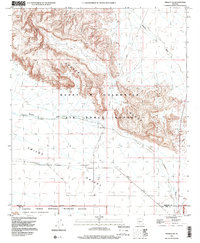
1996 Map of Midway SW
USGS Topo · Published 2000About this map
Childs Valley and the surrounding desert landscape are dominated by federal land designations in this late-twentieth-century study of the Arizona borderlands. The map highlights the extensive footprint of the Barry M Goldwater Air Force Range, which occupies the majority of the central and northern terrain. Along the southern boundary, the transition into the Cabeza Prieta National Wildlife Refuge and the Cabeza Prieta Wilderness is clearly delineated. The landscape is defined by drainage patterns like Tenmile Wash and significant topographic relief. Human presence is limited to utilitarian features such as an Observation Tower and a Gravel Pit, reflecting the area's restricted use for military training and environmental conservation. This survey illustrates the deliberate management of the Sonoran Desert, where vast tracts are preserved for specific governmental and ecological purposes.
Find a feature on this map
10 named features on this map. Tap any name to fly to it.
Don’t see what you’re looking for? This feature index may not catch every label — zoom into the map to look around manually.
Map Details
Editions of this 1996 Midway SW Map
This is the sole edition of this map. No revisions or reprints were ever made.
Other maps of this area

1932 · Ajo
USGS Topo · 1:62,500

1934 · Ajo
USGS Topo · 1:62,500

1953 · Ajo
USGS Topo · 1:250,000

1957 · Ajo
USGS Topo · 1:250,000

1958 · Ajo
USGS Topo · 1:250,000

1958 · Midway
USGS Topo · 1:62,500

1962 · Ajo
USGS Topo · 1:250,000

1963 · Ajo
USGS Topo · 1:250,000

1963 · Ajo
USGS Topo · 1:62,500

1964 · Growler Peak
USGS Topo · 1:62,500