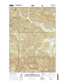
2017 Map of Midway
USGS Topo · Published 2017About this map
The S Yamhill River cuts across the northern landscape of this region, where the borders of Yamhill, Polk, Tillamook, and Lincoln counties converge. Central to the area is Midway, situated along Hebo Rd near the junction of Elmer Cr. The map details a complex network of forest roads and trails, including the SW Old Toll Rd and Sourgrass Rd, reflecting the active timber and transit history within the Siuslaw National Forest.
Find a feature on this map
49 named features on this map. Tap any name to fly to it.
Don’t see what you’re looking for? This feature index may not catch every label — zoom into the map to look around manually.
Map Details
Editions of this 2017 Midway Map
This is the sole edition of this map. No revisions or reprints were ever made.
Other maps of this area

1941 · Nestucca Bay
USGS Topo · 1:62,500

1942 · Euchre Mtn
USGS Topo · 1:62,500

1942 · Spirit Mtn
USGS Topo · 1:62,500

1942 · Nestucca Bay
USGS Topo · 1:62,500

1942 · Valsetz
USGS Topo · 1:62,500

1943 · Euchre Mtn
USGS Topo · 1:62,500

1948 · Vancouver
USGS Topo · 1:250,000

1950 · Vancouver
USGS Topo · 1:250,000

1950 · Vancouver
USGS Topo · 1:250,000

1953 · Salem
USGS Topo · 1:250,000