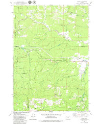
1979 Map of Midway
USGS Topo · Published 1979About this map
The South Yamhill River and Nestucca River headwaters converge in this complex drainage area where four Oregon counties meet. The landscape is defined by the heavy timber of the Siuslaw National Forest and the protected Van Duzer Forest Corridor State Wayside, which preserves a stretch of forest along the highway. Evidence of early community life is visible at the Church in the Wildwood near the northern edge, while the small settlements of Midway, Boyer, and Yates serve as modest centers of activity along the road network. The terrain rises sharply to the south at Saddleback Mountain, a prominent landmark for the region. Extensive resource extraction is documented through numerous quarries, gravel pits, and borrow pits scattered across the hillsides, illustrating the infrastructure needs of the late 1970s.
Find a feature on this map
47 named features on this map. Tap any name to fly to it.
Don’t see what you’re looking for? This feature index may not catch every label — zoom into the map to look around manually.
Map Details
Editions of this 1979 Midway Map
This is the sole edition of this map. No revisions or reprints were ever made.
Other maps of this area

1941 · Nestucca Bay
USGS Topo · 1:62,500

1942 · Euchre Mtn
USGS Topo · 1:62,500

1942 · Spirit Mtn
USGS Topo · 1:62,500

1942 · Nestucca Bay
USGS Topo · 1:62,500

1942 · Valsetz
USGS Topo · 1:62,500

1943 · Euchre Mtn
USGS Topo · 1:62,500

1948 · Vancouver
USGS Topo · 1:250,000

1950 · Vancouver
USGS Topo · 1:250,000

1950 · Vancouver
USGS Topo · 1:250,000

1953 · Salem
USGS Topo · 1:250,000