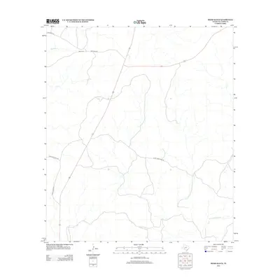
2012 Map of Miers Ranch
USGS Topo · Published 2012About this map
Miers Ranch serves as the primary landmark in this ranching region of Val Verde County, where the landscape is defined by the drainage systems of the Rio Grande basin. The 2012 topography reveals the complex hydrology of the Edwards Plateau, characterized by the winding paths of Big Satan Cr and Bluff Cr. A network of private ranch roads, including Mier Ranch Rd and Tyras Ranch Rd, connects these remote holdings across the arid terrain. The presence of W Fork Sycamore Cr in the southeastern quadrant further illustrates the importance of seasonal watercourses in defining property and territory in this West Texas environment. Genealogists and historians can trace the specific spatial organization of these historic family ranching tracts and their relationship to the primary highway corridor.
Find a feature on this map
9 named features on this map. Tap any name to fly to it.
Don’t see what you’re looking for? This feature index may not catch every label — zoom into the map to look around manually.
Map Details
Editions of this 2012 Miers Ranch Map
This is the sole edition of this map. No revisions or reprints were ever made.
Other maps of this area

1943 · Carta Valley
USGS Topo · 1:62,500

1944 · Flat Rock
USGS Topo · 1:62,500

1944 · Dry Devil
USGS Topo · 1:62,500

1944 · Devils Lake
USGS Topo · 1:62,500

1958 · Del Rio
USGS Topo · 1:250,000

1964 · Del Rio
USGS Topo · 1:250,000

1972 · Miers Ranch
USGS Topo · 1:24,000

1972 · Rough Canyon SE
USGS Topo · 1:24,000
1972 · Satan Canyon
USGS Topo · 1:24,000
1972 · Rough Canyon
USGS Topo · 1:24,000